Copyright © 2026. Encyclopedia Celia

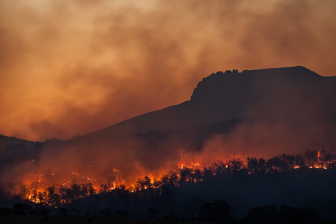
What fires in Kalimantan, Sumatra, and Papua reveal about the way the world treats land—and the people who live on it.
Wednesday, September 30th, 2026—Encyclopedia Celia Team
Some days, the heat makes even simple work feel harder. You sit in an office, stare at a screen, and wait for the air to change. The body has its own way of reminding us that the environment is part of our daily lives.
From inside that room, a complaint about the heat can lead to a more difficult question: what happens when the air where you live is filled with smoke?
I would not equate discomfort at work with living near a fire. The distance between those experiences is considerable, and it deserves to be acknowledged. We can read the news, feel concerned, and return to our tasks. People in affected areas still have to live through the rest of the day there.
Kalimantan, Sumatra, and Papua are more than names that appear in the news when forests burn. These places hold homes, livelihoods, memories, and plans for the future. To discuss the fires is to discuss all of this, including decisions made far from the people who bear their consequences.
The flames we see, the conditions we overlook
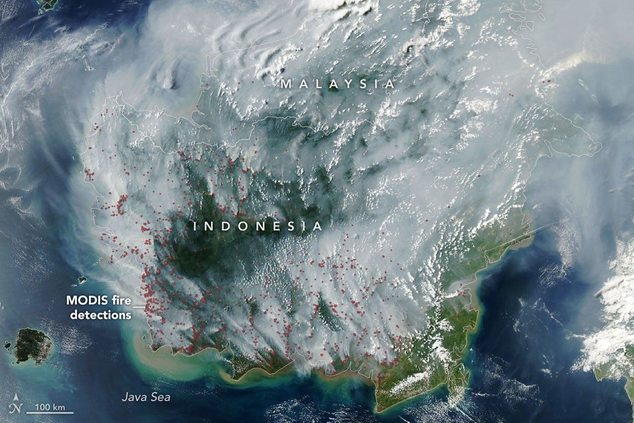
In imagery captured by the Aqua satellite on 1 September 2026, NASA showed smoke and fire detections across Borneo. Its report explains how dry conditions allow fire to spread through peat deposits that would normally be too wet to burn. Below the surface, these fires can smoulder slowly and prove difficult to extinguish. [1]
Understanding them requires us to move beyond the observation that the dry season has arrived. Weather helps explain when conditions become dangerous. Land management helps explain why a place becomes so vulnerable when drought comes.
Peat consists of partially decomposed organic matter accumulated over thousands of years. It stores carbon. Once drained, it becomes more susceptible to fire. The United Nations Environment Programme (UNEP) links forest and peatland fires to the use of fire for land clearance, disputes over land, and drained peat that becomes highly flammable during the dry season. [2]
Calling these fires natural disasters, then, leaves too much unexplained. We also need to examine drainage canals, land-clearing practices, oversight, and the development decisions that came before the flames.
The fire may become visible today. The conditions that allow it to grow may have been taking shape for years.
Three regions, with different stories
Sumatra and Kalimantan—the Indonesian part of Borneo—have a long history of peat fires and haze. NASA’s analysis of the 2015 fire season describes how drought associated with El Niño helped fires spread through drained and degraded peat swamps in both regions. [3]
Papua has experienced fires too. On 24 September 2015, Aqua recorded burning areas and smoke across the Papua and New Guinea region. [4] That record matters, but so does its date. Evidence from 2015 cannot serve as a report on fires in Papua today.
Discussing these places together requires care. A satellite image cannot establish every cause. Nor does a single hotspot necessarily represent a separate fire: NASA explains that one fire can generate multiple detections. [1] Location, land type, and management history must be examined before responsibility is assigned.
Such care strengthens the case for accountability. It allows us to take a position without sacrificing accuracy.
This is particularly important when discussing people whose lives depend on the land. They have knowledge, needs, and a right to be heard. Casting local communities solely as victims, or rushing to treat them as suspects, makes the story easier than it should be.
Cheap for whom?
The World Bank estimated that Indonesia’s 2015 fires cost the country US$16.1 billion [5]. This is a historical estimate, not a calculation of this year’s losses. Even so, it illustrates how far the cost of a fire extends beyond putting it out.
The word “cheap” becomes difficult to defend when the price of clearing land excludes costs passed on to other people. UNEP points out that the apparent savings from burning look very different once health, well-being, and greenhouse gas emissions enter the calculation. [2]
Alongside the question of how much money is saved, we need to ask who eventually pays.
How does a family account for days when work is disrupted? How do we value lost learning time or the anxiety that returns whenever the sky darkens? Economic assessments are necessary, but human experience extends beyond what fits into a spreadsheet.
There is a kind of cruelty that speaks in perfectly ordinary language: calling an activity efficient while sending part of its bill to people who never agreed to pay it.
How the rest of the world enters the story
Smoke does not stop where a map changes color. UNEP notes that Singapore has repeatedly been affected by emissions from peat fires in Sumatra and, to a lesser extent, Kalimantan. The research it discusses also connects land management with health outcomes across Indonesia, Malaysia, and Singapore. [6]
Burning peat releases carbon previously stored in the ground. [2] A local fire therefore becomes part of a wider climate problem. A landscape may have clearly defined administrative boundaries, while its ecological consequences travel far beyond them.
There is an economic connection too. In its discussion of land conversion and fires, NASA notes the use of palm oil in food and fuel. [4] That connection does not justify claiming that every product or plantation causes fires. Establishing responsibility requires evidence, traceability, and distinctions between different practices.
For me, the more useful global question is this: how much are buyers, companies, and financiers willing to know about the condition of the land from which their profits begin?
If the world expects to benefit from a landscape, its attention should remain there too. Concern should not have to wait until smoke crosses a border or interrupts a journey.
The people closest to the flames deserve protection from the beginning.
Caring before something is lost
Prevention rarely produces dramatic images. Peat that stays wet, responders who are prepared, and communities with viable livelihoods may never make international headlines. Yet the World Bank identifies forest and peatland protection, rewetting drained land, alternative livelihoods, early detection, and community preparedness as important parts of addressing the problem. [5]
These priorities suggest concrete demands: fund prevention consistently, scrutinize water management, make information about land control accessible, and act on violations using evidence. Include communities in decisions, especially when they disagree with plans proposed in the name of progress.
Consumer awareness can help, but it should never become a substitute for corporate and government responsibilities. Likewise, asking people to protect nature means providing the support that makes doing so possible.
I want to believe that we can still learn to pay attention. That we can read about a distant place and make room for the lives unfolding there, without waiting for the consequences to reach our own homes.
The heat in my office may have prompted these thoughts. But this essay needs to end beyond that room: with land that deserves care, decisions that deserve scrutiny, and people who deserve to breathe without fear.
Rain can help put out a fire.
It cannot undo every decision that made the land so easy to burn.
Happy Wednesday. Wherever you are reading this, take a moment to think about the air you breathe and the land that makes your life possible. People living closest to the fires deserve our attention long before the smoke reaches us.
For more stories about people, the choices we make, and the things we struggle to put into words, you can also find me on Medium.
~ Fitri ~
Sources:
- NASA Earth Observatory, [Peatland Fires Darken Skies in Indonesia] (https://science.nasa.gov/missions/aqua/peatland-fires-darken-skies-in-indonesia/). Imagery dated 1 September 2026; reporting from early September 2026.
- UNEP, [Why peatlands matter] (https://www.unep.org/news-and-stories/story/why-peatlands-matter), 2019. Peat formation, fire vulnerability, emissions, and the costs of burning.
- NASA, [Severe 2015 Indonesian Fire Season Linked to El Niño Drought] (https://www.nasa.gov/centers-and-facilities/goddard/severe-2015-indonesian-fire-season-linked-to-el-ni%C3%B1o-drought/), 2016. Analysis of the 2015 fires.
- NASA, [Smoke and Fires Pepper Papua Indonesia and New Guinea] (https://www.nasa.gov/image-article/smoke-fires-pepper-papua-indonesia-new-guinea/), 24 September 2015. A historical record, not verification of fires in Papua in September 2026.
- World Bank, [Controlling the burn: Indonesia’s efforts to prevent forest and land fire crisis] (https://blogs.worldbank.org/en/eastasiapacific/controlling-burn-indonesia-s-efforts-prevent-forest-and-land-fire-crisis), 26 October 2016. Estimated losses from the 2015 fires and priorities for prevention.
- UNEP, [The human health benefits of conserving and restoring peatlands] (https://www.unep.org/news-and-stories/story/human-health-benefits-conserving-and-restoring-peatlands), 8 November 2019. Cross-border impacts and research on the benefits of peatland management.